


Pulpit Brook Trail
Map: Open Street Map
Map: NRPC Map
Map: Kiosk Map
Length: 2.5 miles from Horace Greeley Road to Pulpit Rock trail system connection, 1.2 miles from the Pulpit Rock Reservation parking area. The total distance between the trailheads is 3.7 miles.
Identification: White blazes.
Difficulty: Walking: Moderate
Difficulty: Walking: Moderate
XC skiing: moderate with hills and stream crossings.
Mountain biking: Moderate.
Location: There are three points of access:
• Horace Greeley Road in Amherst opposite #106. Limited roadside parking,
• North of Joppa Hill Farm on Joppa Hill Road in Bedford. Roadside parking,
• Pulpit Rock Reservation on New Boston Road in Bedford. Parking area and kiosk showing the Pulpit Rock Reservation trails.
• Horace Greeley Road in Amherst opposite #106. Limited roadside parking,
• North of Joppa Hill Farm on Joppa Hill Road in Bedford. Roadside parking,
• Pulpit Rock Reservation on New Boston Road in Bedford. Parking area and kiosk showing the Pulpit Rock Reservation trails.
The Pulpit Brook Trail lies within an Amherst Master Plan designated greenway running from Grater Woods Town Forest in Merrimack through Pond Parish Town Forest, the Bragdon Farm in Amherst and on to Bedford and New Boston.
Log: From South to north. The trail begins opposite #106 Horace Greeley Road in Amherst and heads north on Old Joppa Hill Road which is a Class VI road going back to colonial times. For the first one-third mile the land on each side is privately owned. Pulpit Brook is crossed on an old concrete bridge where it enters the ACC portion of Joppa Hill Farm (JHF). Formerly a meadow, the upstream area is now flooded by beavers’ construction. This is a good point from which to view muskrats, herons and many little peeps.
At .4 miles as the trail starts to rise, a trail junction is reached and the Pulpit Brook Trail turns left. techniques, all now owned by the ACC. The three parcels comprising these woods were acquired through different mechanisms – bonding, land use change fees and a gift. For the most part, this portion of the trail follows the contour of a glacial flood plain created when Pulpit Brook carried massive flows of glacial melt water.
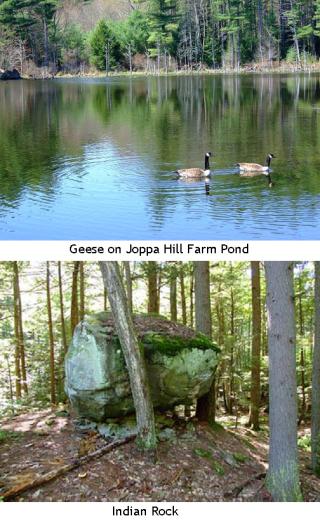
At 1 mile from Horace Greeley Road a junction is reached with the north end of the Joppa Hill Farm Trail (red blazes). From this point via the loop trail, a round trip walk of 2.4 miles can be enjoyed returning to the Horace Greeley trailhead past the Joppa Hill Educational Farm. The Pulpit Brook Trail continues north blazed in white. For the next 1,000 feet the trail makes use of a former skidder or tote road. On the right the woods which were cut in the 1980s are predominated by red maple and moister conditions. To the left, across the stone wall, the older pines are growing on drier and sandier soil with less understory. Logging in this parcel by a different owner took place much earlier. The trail crosses a small brook 1.2 miles from Horace Greeley Road and continues through a stand of mature pine on a slightly raised area paralleling Pulpit Brook wetland. Cross one skidder road and continue 100 yards to join a second skidder road. Turn right on this road through an area of young forest recovery. This is a place where the importance of new growth, shoots and saplings in supporting rabbits, turkeys and other forest folk is demonstrated. Tracks and signs of them are particularly evident in the winter on snow.
At 1.3 miles the trail passes through a stone wall, entering older pine and hemlock woods and starts climbing. For the next .4 miles the trail roughly follows a hillside contour 380 feet above sea level. It crosses several small seasonal streams with Pulpit Brook flowing below. The trail in this section is placed on private property through the courtesy of the owner. The trail turns west to cross a stream and rise steeply to the top of a relatively open knoll. This is the high point of the trail. From here it drops slowly to cross a stone wall 1.7 miles from Horace Greeley Road. The wall is on the Amherst-Bedford town line. From the wall to Pulpit Rock Reservation the trail lies on development open space and Bedford Conservation Commission managed land. The trail continues north, dropping through mixed woods and over seasonal streams to reach a wet area of grass, moss and ferns. After crossing several small streams, climb a small pine-topped knoll which affords a survey point of the woods and wetland below. Descend from the knoll past a rusted sickle-bar chassis, long since left for another year’s harvest which has yet to come. In 150 feet the trail meets a wood road 2 miles from Horace Greeley Road. To the right, the wood road follows a stream up .25 mile to Pulpit Road Bedford. Pulpit Brook Trail goes left on the wood road across the stream to where it goes into the woods on the left and soon reaches Indian Rock, a glacial erratic. Cross a small stream by the rock and rise into a heavily cut over area. The historic Sprague Mill dam is a short distance to the left. The trail continues, skirting the wet area upstream of the former mill dam and goes over a granite ledge formation to end on the Bedford Conservation Commission Campbell Trail, blazed in red, 2.2 miles from Horace Greeley Road and 1.8 miles from Joppa Hill Farm. To the left the red trail crosses Pulpit Brook on a bridge leading to the Tufts Trail blazed in white, the mill dam and Pulpit Rock Reservation parking lot on New Boston Road where there is a map kiosk. To the right the red trail also goes to Pulpit Rock and the Reservation parking lot on New Boston Road.