


Baboosic Greenway: Amherst South-03
| Organizational note |
|---|
| This initiative is a segment of the Baboosic Greenway regional project. |
Baboosic Greenway segment Amherst South-03 is situated between Baboosic Greenway segment Amherst South-02 to the north and Baboosic Greenway segment Amherst South-04 to the south, at a proposed midblock crossing across Boston Post Rd. This segment is where the route, as it travels from north to south, begins to diverge from the route of the former Milford and Manchester Branch rail bed, rather opting for a southeasterly trajectory, in order to provide a direct connection to the southern school campus area.
Location
This segment of the Baboosic Greenway is in southern Amherst, between Merrimack Rd and Boston Post Rd. It spans 6,666 linear feet along Beaver Brook, the Souhegan River, Fairway Dr, and River Rd.
| This project connects directly to other segments of the Baboosic Greenway | |
|---|---|
| To the north | This project connects to Amherst South-02 at Merrimack Rd |
| To the south | This project connects to Amherst South-04 at Boston Post Rd near River Rd |
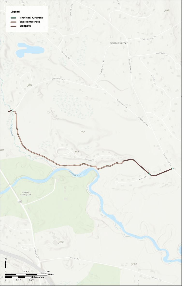
Map of the proposed treatments and routing of Amherst South-03
Purpose
The purpose of this project is to complete a segment of the Baboosic Greenway by the establishment of ROW and a shared-use path connecting the southern school campus area to destinations in the center and north of town, including the rest of the Baboosic Greenway. This segment of the route has perennially appeared in local plans, studies, and requests in the Town of Amherst as it stands to serve a crucial role in a north-south alternative transportation corridor in town, with hopes of connecting the Amherst Village to the southern school campus area.
This project continues to build out the mission of the Baboosic Greenway, which stands to create a regional spine for a broader off-road trail network for the purposes of enhancing safety, increase regional mobility, and expand accessibility for persons who are unable to transport themselves by motor vehicle.
Connectivity-focused facilities such as these provide area residents with a unique opportunity to move throughout their town and the region off-road, offering a peaceful journey reduced interaction with motor vehicles. This can provide exceptionally safe and convenient mobility for multimodal users, especially if they are a member of a vulnerable population or if their route would otherwise take them on a busy roadway.
Need
This particular segment of the Baboosic Greenway offers a direct, parallel route for users to bypass Merrimack Rd and Boston Post Rd between the School Campus area and the Amherst Village area. This portion of Merrimack Rd and Boston Post Rd has a fairly narrow ROW, horizontal and vertical sight distance problems, narrow shoulders, and is generally seen as dangerous for nonmotorized users. By providing a safe alternative along one of Amherst’s highest volume roadways, this project would represent a significant accomplishment toward developing an area-wide, safe alternative transportation network.
Data
Calculating the data of this project, linear feet numbers of each treatment are provided below:
| Treatment | Detail | |
|---|---|---|
| Full segment extent | 6,666 linear ft | |
| Including | Shared-Use Path (Crushed Stone, 10’ typical section with 2’ shoulders) | 4,696 linear ft |
| Sidepath (Asphalt, 8’ typical section with >5’ separation from roadway, terra cotta hot mix colorant added to top layer) | 1,844 linear ft | |
| Midblock Crossing (at Boston Post Rd, RRFB with refuge island, and lighting) | 1 | |
| Right-of-way (for shared-use path) | 301 linear ft | |
Project Status
The current status of Amherst South-03 is as follows:
| Date | Update |
|---|---|
| 2024-April | This project was included in the draft Ten Year Transportation Improvement Plan (TYP) by the state legislature as project 44351 |
| 2022-May | This project was added to the Nashua regional Metropolitan Transportation Plan (MTP) |
| 2022-May | This project was submitted for addition to the Ten Year Transportation Improvement Plan (TYP) but was not selected due to funding limitations |
| Attachment | Size |
|---|---|
| 1.93 MB |