


Pond Parish Trails
Map: Open Street Map
Map: NRPC Map
Pond Parish Trail - Red blazes.
Pond Parish Loop - Yellow blazes.
Beaver Dam Overlook - Orange blazes.
Josiah Parker Trail - White blazes.
Difficultly: Walking: Easy,
Difficultly: Walking: Easy,
XC: Easy
Location: Parking lots and trailheads are located on Pond Parish and Spring Roads.
Here is a land in transition. Change is occurring around us in a progression of natural processes. Abrupt changes have occurred in the past from human intervention. During your visit, you can enjoy the smells, sounds and sights of the woods and marsh. You can see signs of the uses by residents 100 years ago and developers within recent history. The pond and marsh are relatively recent changes made by one of nature’s change agents – the beaver. This reservation is a key hub in the greenbelt that connects open woodlands in Merrimack with lands across Amherst and beyond into Bedford.
Recent History:
Five parcels of land that now are called the Pond Parish Town Forest (PPTF) belonged to several owners until they were assembled by a developer in the 1960s. Old stone fences mark some of the bounds and tell us that most, if not all, of the area was once cleared land. The Converse family, which owned some of the land, operated a sawmill
across Pond Parish Road from the east entrance to PPTF. The old dam and mill foundation still stand. The millpond has become a bog supporting black spruce and carnivorous plant populations. The Converses also donated land for District School No. 6. The stone wall, which apparently kept the cows out and the students in, is on one of the properties south of the east entrance. In 1991 the property was heavily logged for saw logs and cordwood. In one area so many trees were removed that the remaining pines lacked support and were further decimated by high winds. In 2010 a much more controlled selective cut was made by the ACC on the higher land west of the marsh. This cut, as are all ACC forest management activities, was planned, laid out, and overseen by the Commission’s professional forester.
Property Description:
The land around you was shaped by the ice age glacier 10,000 years ago. This left the soil at the south end of the PPTF sandy and easy digging. At the north end, the soil is laden with boulders as witnessed by the new stone wall around the east entrance lot and along the trail. A few large glacial erratics dot the forest floor midway along the trail. An erratic is a boulder out of place, a natural error that was transported by the moving ice sheet. In the case of these erratics, they may have been plucked from the south cliffs of Joe English Hill or may have traveled from a mountain far to the north. The central area of the reservation is a 100-acre wetland stretching from Baboosic Lake Road to Spring Road. In a review of the wetlands in town, this area was ranked fifth in total value, only a little below
Baboosic Lake and Witches Spring. The ranking takes into account wetland size, ecological values, aquifer recharge, educational uses and several hydro-geological factors. The Pond Parish wetland divides roughly into thirds with each part having significantly different characteristics. At the south end, a beaver dam creates an open water pond of approximately 30 acres. Under the pond there is less than a foot of muck over the underlying
gravel, indicating the pond builders are relatively newcomers, flooding what was once meadow. Upstream to the north, a slight elevation change in the vicinity of the observation deck changes the pond into a marsh area. Here grasses and shrubs encroach on the stream but leave the wetland generally open. The highest third of the wetland lies north of the logging trail. Here taller red maples are growing and tall ferns cover the ground. Some pines and hemlocks maintain a tenuous foothold on raised hummocks. However they show signs of stress produced by the water level being too high at times. On the pond, geese and ducks are frequent visitors, swimming around the beaver lodge. The transition buffer between the pond and the upland woods is an active zone for small birds, residents and migrants. It is fortunate here that a wide woodland buffer can be maintained. Many species of birds and amphibians require a buffer several hundred feet wide for breeding. In other wetlands around town even though
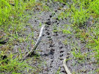
the wetland is identified it is not possible to create an ecologically satisfactory buffer around it. The observation deck is placed in this buffer. The upland portion of the property is primarily forested with oak, pine and hemlock woods. From tracks and scats it is seen that deer, moose, coyote, fox and mink move through the area, even if they are not
residents. As the understory recovers, the woods will be more hospitable to the larger species.
Baboosic Lake and Witches Spring. The ranking takes into account wetland size, ecological values, aquifer recharge, educational uses and several hydro-geological factors. The Pond Parish wetland divides roughly into thirds with each part having significantly different characteristics. At the south end, a beaver dam creates an open water pond of approximately 30 acres. Under the pond there is less than a foot of muck over the underlying
gravel, indicating the pond builders are relatively newcomers, flooding what was once meadow. Upstream to the north, a slight elevation change in the vicinity of the observation deck changes the pond into a marsh area. Here grasses and shrubs encroach on the stream but leave the wetland generally open. The highest third of the wetland lies north of the logging trail. Here taller red maples are growing and tall ferns cover the ground. Some pines and hemlocks maintain a tenuous foothold on raised hummocks. However they show signs of stress produced by the water level being too high at times. On the pond, geese and ducks are frequent visitors, swimming around the beaver lodge. The transition buffer between the pond and the upland woods is an active zone for small birds, residents and migrants. It is fortunate here that a wide woodland buffer can be maintained. Many species of birds and amphibians require a buffer several hundred feet wide for breeding. In other wetlands around town even though
the wetland is identified it is not possible to create an ecologically satisfactory buffer around it. The observation deck is placed in this buffer. The upland portion of the property is primarily forested with oak, pine and hemlock woods. From tracks and scats it is seen that deer, moose, coyote, fox and mink move through the area, even if they are not
residents. As the understory recovers, the woods will be more hospitable to the larger species.
The Future:
We said this land is in transition. The characteristics of the wetland could change almost overnight depending on the whims of the beavers. If they leave, get flooded out or fail to maintain the dam, the pond area could recede and the marsh expand. If the beaver build another upstream dam to be closer to food, the maple swamp could become a pond marked by downed tree trunks. The beaver is a very effective change agent. Without intervention, the forest will mature and the wetland will continue to be managed by the beaver. Beneath the surface, the groundwater will be protected and be a source of recharge to the aquifer. The ACC plans to let nature manage the wet areas. The
upland on the west side is a managed woodlot.
North Section Trail:
This section of the Pond Parish trail system is a loop that goes west from the Pond Parrish Town Forest parking lot on Pond Parish Road. The kiosks at the trailhead and the parking lot were constructed as Eagle Scout projects.