


Lindabury Orchard
Length: 3/4 mile (one way, both trails)
Identification: Orchard Loop - White blazes.
Difficulty: Walking: Moderate
X-C Skiing: Moderate
Directions: Take Christian Hill Road from Amherst village, or from route 13 to the top of the hill. The orchard is on the south side of the road at the top.
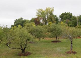
The 47 acre property known as the Lindabury Orchard actually contains a significant amount of wooded land. It falls away south from Christian Hill Road at a gentle grade, transitioning from orchard to heavy forest near the bottom of the hill. Parts of the orchard near Christian Hill Road offer scenic views to the southwest. A drainage gully separates the orchard into the smaller upper orchard on the left and larger lower orchard on the right. There are two trails on the Lindabury property. The “Orchard Loop” originates and terminates in the upper orchard where the orchard and forest meet. The Lindabury Trail begins at the top of the lower orchard near Christian Hill Road, traverses the lower orchard into the forest, and intersects with the Orchard Loop trail at its southern point. Brief descriptions of these two trails follow.
The orchard is the site of occsional comunity events, including the Cider Festival, which is held in the fall most years. The Friends of the Orchard always appreciate volunteers to help maintian the orchard and to help run the Cider Festival.
Orchard Loop Trail. The Orchard loop Trail is marked with white rectangular blazes. It is a U-shaped trail originating and terminating approximately 100’ apart in the upper orchard where the orchard and the forest meet. This description begins on the left trailhead, but one may start the trail from either point. The trail head sign is found on the right side of the trail just at the wood line. Generally the trail slopes gently downhill all the way to its southern point, where it turns north and gradually climbs uphill to its terminus point. The trail begins on the remnants of an old farm or woods road. By the first white blaze on a large pine on the left side of the trail is a large glacial erratic 30’ off the trail. At this point the trail veers right off the old road into the woods. You now walk among large pines, many of similar size, with new maple and beech saplings making up the understory.
At a large pine with white blaze on your left the trail turns right 90°. After 100’ and just beyond another large pine with blaze on your left the trail takes a hairpin turn to the left and goes between two large rocks in the trail. Just beyond the rocks you merge briefly again with the woods road, now heavily eroded. You enter a small clearing with many large rocks and boulders on either side, followed by a second small clearing. The trail continues to the right, 100’ beyond which you pass through an opening in a stone wall and the descent begins to flatten out. Passing between two large pines, the right one blazed, the trail then turns right, followed, after 75’ with a left turn. Here the trail is flat and the forest floor is covered with ferns. Ahead you come to the junction with the Lindabury Trail. You have reached the southern end of the Orchard Trail, which now turns right, then after 50’ turns right again and begins the gradual ascent uphill back to the upper orchard. Just ahead on your left as you begin the gentle uphill climb is a massive, 4-trunked pine, one of which has broken off, and the remains of which lie on the right of the trail. On the left is a stream that drains the orchard fields. In the spring it is full with the runoff; by late summer or fall it is dry except after a heavy rain. Behind the stream is a ridge that is traversed by the Lindabury Trail. You are now walking uphill on the remnants of another farm or woods road. As you leave the woods and come into a field and old orchard you pass through a stone wall that you had previously crossed during your descent of the Orchard Loop. It continues to the left and you would cross it again on the Lindabury Trail. To your right, and paralleling your path is a north-south stone wall, while to your left you have views of the large, lower orchard. After several hundred yards, a concrete post marks the end of the north-south stone wall, and you briefly re-enter woods. Ahead you can see the end of the woods where they open onto the upper orchard, and also mark the end of the Orchard Loop trail.
Lindabury Trail. The Lindabury Trail, marked with red, rectangular blazes, begins at the top of the lower orchard just off Christian Hill Road. On your right is a small wooden pump house used at one time to provide water to the orchard. It is on private property and should not be approached. The trail winds through fields and what is left of the apple orchard, with apple trees on your left, and a hay field to the right. This portion of the trail is kept mowed, and used as the hay ride path during the fall Cider Festival. There is lots of poison ivy off the mowed trail, as well as in the remaining apple trees, many of which are still producing apples yearly. Ahead, where the hay ride path turns left or right, stay to your left. The trail follows an “s” path through the trees and offers scenic views to the southwest. To your right is a larger, wooden shed that was used for storage when the orchard was actively farmed.
At the bottom of the orchard field the hay ride path turns right. The Lindabury Trail goes straight ahead, where a nice stone wall marks the boundary between orchard and forest. Shortly after entering the forest the trail starts a steep descent. To your left is a stream that in the spring is full of runoff from the orchard fields. By late summer, except after heavy rains, it is dry. After reaching the bottom of the descent you begin to climb a north-south ridge that provides nice forest views to your left and right. The top of the ridge is marked by scattered, large pines with beech and maple sapling undergrowth. Shortly you begin a long, gradual descent off the ridge, which ends at a large pine on your left and a forest floor of ferns ahead. The trail takes a 90° turn to the left. Ahead is a short bridge over the stream that was on your left as you entered the forest. Crossing this short bridge, you take another 90° turn to the left and come to the junction with the Orchard Loop and the end of the Lindabury Trail.