


Old Brook Road Trail
Map: Open Street Map detail
Map: NRPC Map detail
Length: 0.4 miles PMEC kiosk to dead end at NBAS gate
Identification: Red Blazes
Difficulty: Walking: Easy
Identification: Red Blazes
Difficulty: Walking: Easy
XC skiing: Easy
Mountain biking: Not allowed.
This section of Brook Road was abandoned as a public way when the Army Air Corps acquired 2700 acres of Amherst, Mont Vernon and New Boston for use as a bombing range during World War II. Now belonging to the ACC, it is used as a trail for walking and XC skiing. Public access is denied on the old road beyond the gate at the New Boston Air Station property line. Old Brook Road, as well as being
pleasant in itself, provides the initial trailway access to several other trails on both the east and west sides of Joe English Reservation.
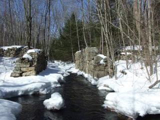
Log: The trail follows the old road north from the PMEC parking lot. It passes the red cottage that was home to the mill’s sawyer and his family. (Visit the display in PMEC to see historic photographs). Some of the stonework of the mill dam and foundation remain. Joe English Brook flows where once the waterwheel turned for 100 years. Upstream of the Peabody Mill, three other mill sites, now located inside NBAS, utilized the hardworking water of the brook. Now the dam is a refuge for small animals and a tribute to the creative energy of our ancestors.
At .1 miles from the cottage, Post 6, the Highland Trail (blue) exits right.
At .3 miles, Post 7, the Ledge Trail (red) exits right and at Post 8 the Timber Trail (orange) exits left. The old road continues 500 feet further to a bench with views of Joe English Brook and Marsh. Passage around or beyond the NBAS gate is prohibited by the Air Force for reasons of personal safety and national security.