


Patch Hill Trails
Map: Open Street Map
Map: NRPC Map
Map: Patch Hill Kiosk Map
Length: Patch Hill Trail: 1.2 miles to Chase Lane (Milford) trailhead.
Old Skid Road Trail: 0.5 miles
Harold Wilkins Trail: 0.6 miles
Identification: Patch Hill - White blazes.
Identification: Patch Hill - White blazes.
Old Skid Road - Blue blazes
Harold Wilkins - White blazes
Difficulty: Walking: Moderate.
Difficulty: Walking: Moderate.
XC skiing: Difficult.
Mountain biking: Moderate.
Directions: Amherst St. towards Milford to right on Lyndeborough Rd. .75 miles to trailhead on left (south). Parking on road.
Patch Hill, elevation 568’, lies on the border of Amherst and Milford to the south. Trails in this area are maintained by both the Amherst and Milford Conservation Commissions. This trail could just as well have been called the Quarry or Granite Trail since much of the trail is underlain by a granite dome. The trails pass four prominent quarries. There are at least three others and several locations where the exposed granite ledges offered easy pickings. Limited views of the Souhegan Valley and hills to the north and west are possible from openings in the forest where the trail crosses bare granite openings. The bare ledges arose from a combination of fires and glacial scouring. As you cross these ledges note the fissures in the granite dome which continues to be fractured and eroded by frost and differential expansion of the crystals of its different mineral constituents. The slow process of recapture by the forest is seen beginning with lichens and mosses which cling to the exposed rock. In time soil will be created and herbaceous plants and trees will take root. This trail route illustrates the several ways that land may be kept in a natural state for public enjoyment. Some parcels were donated to the commissions, some purchased, and another protected by an easement held by the Milford Conservation Commission.
Log: The Patch Hill Trail begins at a kiosk with map on the south side of Lyndeborough Road opposite street number 47. The map shows the trail route in Amherst and Milford The trail rises on an eroded tote road which has historically been used to bring out granite from the quarries and timber from the woods. The first quarry is reached in 100 yards. The granite foundation of the compressor house still stands, block on block. At 150 yards one of the small excavations is passed on the right. This may only have been a test operation to determine the quality of the stone. Another larger quarry is reached on the left at 950 feet from the kiosk. Note here the large amount of stone that was removed and scrapped. Porcupines and foxes have used cavities in these piles for their dens.
At .3 miles the hemlock and pine woods are left and maple and beech now grow in an area that was cut heavily. Several skidder roads cross in this area. The white blazed trail goes right.
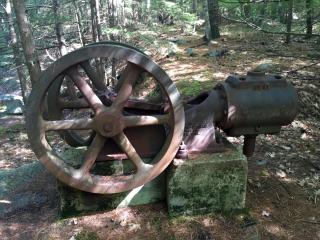
At .4 miles another larger quarry is skirted. One of the gin pole derricks still stands beside the water-filled quarry. Just past the quarry an air compressor manufactured by Ingersoll & Sargeant Drilling Co. still rests on its foundation as it has for nearly a century. Note in this area many hemlocks look like they were pruned. They were – by porcupines. Since porkies prefer to eat close to home, this is another sign that they were finding dens amongst the discarded rock. Shortly a double blaze marks where the trail becomes a foot path and leaves the tote road to the right.
At .5 miles the trail crosses the Milford town line onto Milford Conservation Commission land. Diamond-shaped signs announce this is a “Milford Public Hiking Trail”. These markers also are used to indicate abrupt changes in trail direction. The main trail divides at a sign post. This description follows the left hand (eastern) route. The left-hand trail proceeds across bare ledges with limited views then descends via gentle switchbacks until at 1 mile the western loop trail re-enters right. A map is posted here. The trail continues to the trailhead and kiosk on Chase Lane. A good return route (going north) is via the western loop which leaves left at the junction where a map is posted .2 miles from Chase Lane and 1 mile from Lyndeborough Road. This leg of the trail which is all in Milford passes behind the Quarry Condominiums on easementprotected land and then turns upward past quarries. Again note the amount of unused stone and porcupine-chewed hemlocks. Rejoin the main trail at the town line .5 miles from Chase Lane. Go left to return to Lyndeborough Road and Amherst.
At .5 miles the trail crosses the Milford town line onto Milford Conservation Commission land. Diamond-shaped signs announce this is a “Milford Public Hiking Trail”. These markers also are used to indicate abrupt changes in trail direction. The main trail divides at a sign post. This description follows the left hand (eastern) route. The left-hand trail proceeds across bare ledges with limited views then descends via gentle switchbacks until at 1 mile the western loop trail re-enters right. A map is posted here. The trail continues to the trailhead and kiosk on Chase Lane. A good return route (going north) is via the western loop which leaves left at the junction where a map is posted .2 miles from Chase Lane and 1 mile from Lyndeborough Road. This leg of the trail which is all in Milford passes behind the Quarry Condominiums on easementprotected land and then turns upward past quarries. Again note the amount of unused stone and porcupine-chewed hemlocks. Rejoin the main trail at the town line .5 miles from Chase Lane. Go left to return to Lyndeborough Road and Amherst.
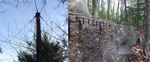
Crane for lifting granite slabs. Drill holes for feathers and wedges used to split rock face