


Eagle Trail
Map: Open Street Map detail
Map: NRPC Map detail
Length: 0.75 miles, Post 3 to Post 5
Identification: Yellow Blazes
Difficulty: Walking: Moderate,
Identification: Yellow Blazes
Difficulty: Walking: Moderate,
XC skiing: Tricky, not recommended
Mountain biking: Not allowed
The Eagle Trail begins at Post 3 on the Hammond Brook Trail .6 miles from the PMEC parking lot. The trail runs three-quarters of a mile to its end at Post 5 on the Timber Trail. It has several abrupt changes in direction and slope, making it poor for XC skiing. Walking and snowshoeing are good for the more energetic person. The trail was laid out and cut by Eagle Scout Glenn Spargo in 1977 under the guidance of ACC member Herbert Harding.
Log:
At Post 3 on the Hammond Brook Trail turn right (north). The first .15 miles goes through hemlock woods. Note how the tree roots are near the surface to stay above the water table. Gold thread with its trefoil leaves and golden roots is a ground cover wildflower in this wetland. Rectangular holes in decaying trees are the signature of a pileated woodpecker, the largest woodpecker in this area. The trail now rises out of the wetland into a beech and maple grove on the drier hillside. Reach Post 4 at .2 mile.
At Post 4, the yellow-blazed Eagle Trail turns right. (Straight-ahead is the blue-blazed Hammond Brook Trail.) The Eagle Trail rises and continues over uneven ground for .3 mile. Note the variation and variety of tree and shrub species as the trail rises over drier ledges or dips into moister sections.
At .45 miles, by a seasonal stream, the following tree species are near the trail. Can you spot these: yellow, black and white birch, poplar, red oak, beech, hemlock, red maple, witch hazel, white pine and mountain laurel.
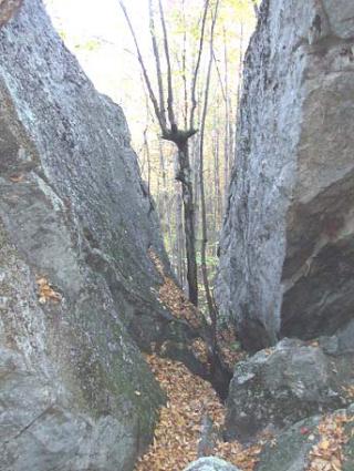
At .5 miles, large boulders on the left probably were plucked from the south cliff of Joe English Hill, one mile to the north, by the ice age glacier 10,000 years ago*. From here, the trail drops to the edge of a swamp. Large black gum trees (tupelo) can be seen with their deeply furrowed bark and irregular tops, distorted by decades of ice and summer storm gusts. In the neighborhood of 500 years old, these are among the oldest trees in Amherst, surviving because of the wetland’s moat-like barrier and the low quality of the gum wood as a building lumber. The trail continues .2 miles to its terminus at Post 5 on the orange blazed Timber Trail, passing through a mixed hard and softwood forest. Note the white quartz now appearing in some of the granite boulders. The trail parallels the blue-blazed NBAS boundary. See the general notes and precautions regarding trespass. The results of the glacial process created hills shaped like Joe English Hill which rises gently on the north to a chopped off south end cliff. The blocks of granite would be carried by the moving ice sheet, grinding and being ground. The large isolated boulders would eventually be dropped as the ice ceased moving and melted. Called
“erratic”, examples can be found at many ACC trail locations such as in the Haseltine and Pond Parish Reservations.
* The glacial ice at its peak was a mile deep over Amherst. The weight of ice put a pressure approaching one ton on every square inch of the land. The compressed ice would freeze to the bedrock ledges of the hills. As the glacier inched south, the forces would pull on the ledges breaking pieces of the granite hillside away from the south slopes.