


B & M Trail
Map: NRPC Map
Map: B&M Trail Kiosk Map
Length: 1 mile (no loop)
Identification: Occasional blue blazes.
Difficulty: Walking: Easy.
Length: 1 mile (no loop)
Identification: Occasional blue blazes.
Difficulty: Walking: Easy.
XC Skiing: Easy.
Mountain biking: Easy.
Directions: Route 101 north to Walnut Hill Road on right. Go over hill 1 mile to trailhead on right. Parking on the road.
The B & M Trail is named for the Boston & Maine RR which constructed this short-lived branch line to preclude another corporation from capturing the Amherst and Milford market. The trail offers a level walking or XC skiing experience nearly unique in Amherst. It shows the efforts railroad constructors had to muster even in these flat lands. Part of this right of way is on privately owned land, and the trail has been closed off at about the 1 mile mark. The trail can only be entered now from the north end. The north end is on Walnut Hill Road near the junction with Clark Island Road where limited parking is possible.
Log: North to south. Traveling south from Walnut Hill Road, Little Baboosic or Weston Pond, as it was once called, is on the left. At the far end of the pond the former Parker farm built in 1774 can be seen. Below the farm, the ACC owns 6 acres at the opposite marshy end of the pond. On that site, a pile of sawdust that was blown into what is now wetland is the only evidence of a former sawmill. Near at hand, the pond is slowly filling in as royal ferns and cattails grow in the shallow water where the level is controlled partly by beavers. Note the size of the trees in the old right of way. How long ago do you think it was when the last train passed here?
At .1 miles, on the right, is a group of granite boulders (erratics) which remained after the glacial ice retreated 12,000 years ago. Other cut stones on the side of the right of way probably were waste from a quarry on Walnut Hill. On the left, a clearing in a red pine stand on private property is used by the farm on the right for storage.
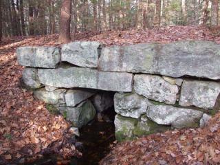
At .3 miles, the trail stays above the bordering land on a man-made embankment. Farm lanes come in to the right of way from each side at .5 mile. Did the farmers meet the train here with their milk cans for the city? The privately owned farm lane (trail) to the left leads to Baboosic Lake Road. In 200 feet further, the trail goes into a rock cut where the granite was blasted away to create an even grade for the locomotives to pull. The trail continues for half a mile in mixed woods. Signs of former pastures are evidenced as stone walls are passed. Some of the walls were crossed or buried by the railroad, showing that the walls and the animals they enclosed far preceded the iron horse.
At 1 mile, the trail used to continue across privately owned land adjacent to Dream Lake. This water body was created as gravel was excavated. The trail is now closed and fenced off at this point.