


B-H Trail
Map: Open Street Map
Map: NRPC Map
Map: Kiosk Map (see B-H trail near bottom)
Length: 0.5 miles
Identification: Orange blazes
Difficulty: Walking easy,
Identification: Orange blazes
Difficulty: Walking easy,
XC skiing: Not recommended
The B–H Trail provides a connection for hikers between the Haseltine Trails and the Bicentennial Trail. The route is placed on land obtained by the Town through a bargain sale in 2009 for conservation purposes.
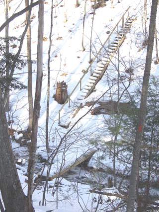
Log: The trail leaves Austin Road west of Dodge Road and 500 feet east of the Haseltine Community Preserve parking area. Going north from Austin Road, the trail soon reaches a gully and crosses a small stream on a bridge. It rises from the bridge on a flight of stairs built by ACC volunteers. The trail continues through mixed woods and rises to a drier, more open area. Here red cedars are growing. This species is not too common along our trails except in former fields where the cedar is a pioneer species. Cedars are a winter feed for browsing deer so it is not unusual where they are growing to find them pruned of needles up to the height a hungry deer can stretch. The trail drops from the knoll to end on the Bicentennial Trail. To the right the Bicentennial Trail leads to Austin Road in .4 mile. The Bicentennial – Arnold Trail junction is .1 mile to the right (south). The Lorden Path junction is .25 miles left (north).